I’m very pleased that my colleague John Hess has agreed to do a guest blog post to help commemorate the anniversary of the Civil War battle at Antietam/Sharpsburg. Fought near Antietam Creek close to Sharpsburg, Maryland on 17 September 1862, the battle created over twenty-two thousand casualties and remains the single most violent day in U.S. history.
John visited the historic battlefield site this summer and took a number of photographs that reveal history in a way that written description alone often cannot. Simon Schama helped us realize in Landscape and Memory (1995) that the natural world can profoundly influence popular memories and histories. But a twist on that idea can be true as well: we can forget what landscapes look like to the detriment of how we remember and understand historical events.
Anne Kelly Knowles (Middlebury College) has used GIS technology to change how we view Civil War history, particularly the Battle of Gettysburg. For example, by melding topography and top-down geography she has questioned whether Confederate General Robert E. Lee could actually see much of the battlefield, possibly helping explain some of his militarily ineffective decisions. In a similar way, we now turn to John’s guest post for how his photos can help explain why the battle at Antietam unfolded the way it did.
**note: Obviously landscapes and environments can and do change over time. The authors recognize that, while the battlefield likely looked very similar to how it does now, it did not, in 1862, look exactly as it does today.
** ** ** ** **
One hundred and fifty-three years ago today, Robert E. Lee’s Army of Northern Virginia met the Union Army of the Potomac, under the command of General George B. McClellan, near Antietam Creek in a rural area of western Maryland. After victories over Union armies during the Peninsula Campaign and the Second Bull Run, Lee embarked on an invasion of the North in the fall of 1862. He hoped that Confederate victories on Northern soil would bring European recognition of the Confederacy, particularly from Great Britain and France. The invasion began well enough for Lee. Dividing his army into three columns, he sent General Stonewall Jackson to capture an important ammunition depot at Harpers Ferry, Virginia, while the rest of the army moved into Maryland. Lee’s invasion may have worked against the ever-cautious McClellan, but fate then seemingly intervened. Two Union soldiers found a copy of Lee’s orders wrapped around some cigars and immediately forwarded those to McClellan. The Union general now possessed the ability to destroy the Army of Northern Virginia, but he once again moved slowly. On September 17, 1862, the armies met east of the small town of Sharpsburg, Maryland, along Antietam Creek. McClellan outnumbered Lee almost two-to-one, as rebel regiments were still marching from Harper’s Ferry. Nevertheless, the Confederates held geographic advantages on the battlefield and what followed was the bloodiest single day in American history.

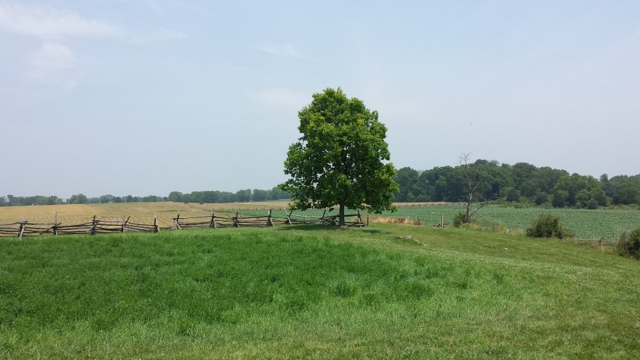
Above: A panorama of the northern part of the battlefield. This pictures looks west towards Sharpsburg.
The engagement began with Union attacks on the northern edge of the battlefield (shown above). Union regiments advanced out of the north woods southward towards Confederate positions over a broad, flat field. Marching north to south (right to left in the picture), the terrain provided ideal for keeping formation. But that flatness exposed Union regiments to withering fire from rebel artillery and provided no cover from flying shrapnel.
Above: The view northward across the old cornfield.
The Union advance produced one of the bloodiest engagements of the Civil War. In the picture above, which looks northward into where the cornfield once stood, you can see how open the terrain was. Advancing Union soldiers would have made easy targets to Confederate artillery batteries. Now imagine a large cornfield, with stalks nearly as tall as a grown man. Confederate soldiers waited on the southern edge of the cornfield and met Union soldiers with a wall of soft lead as they moved out of the cornfield. A young Union private, marching in line out of the cornfield, would have had to adjust to the relative brightness after the cornstalks blocked out much of the sun. Coupled with massed Confederate rifle fire, the battle in the cornfield would have been confusing and chaotic. The infamous cornfield ultimately changed hands several times during the early morning hours and the fighting produced thousands of casualties on both sides; in some units, 60% of the men were killed or wounded in just a few hours.

Above: Looking west towards the Confederate positions in the West Wood.
After the Union eventually secured the cornfield, a fresh division under the command of General John Sedgwick joined the battle and the new forces pivoted to the west with hopes of rolling up the Confederate flank. Sedgwick’s division of some 5,000 men advanced into the West Woods where it met withering fire from three different directions: artillery from the west, along with infantry and cavalry units to the south and southwest. The close confines of the West Wood, as seen above, combined with the smoke of battle to produce organized chaos. Soldiers and commanders would have had little idea what was going on beyond their immediate vicinity. Additionally, the forest broke up unit formations, meaning it was difficult, if not impossible, for Union regiments to attack in mass, negating their numerical superiority. As a result, Northern units suffered horrendous casualties. The Philadelphia Brigade, for example, lost some 500 men in less than twenty minutes of fighting in the West Wood.
The advance into the West Wood also brought the fighting to a small, white-washed church built by a sect of German pacifists: the Dunkers. Since it was so near to the forest, the little church became a small battlefield unto itself, as Union and Confederate regiments fought to control this small, but important geographic landmark just south of the West Wood.
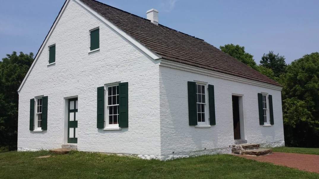
Above: The reconstructed Dunker church. It was a focal point of fighting as the battle shifted to the south and west during the morning hours.
As fighting raged in the West Wood, two Union divisions advanced (east to west) in the center of the battlefield. Some 10,000 Union soldiers attacked approximately 2,500 Confederate soldiers defending the center of the line in the sunken farm road seen below..

Above: Looking south along the sunken farm road. Union regiments advanced from the left
The sunken road stretched for several hundred yards in the middle of the battlefield and provided a natural trench for Confederate regiments. As a result, rebel soldiers could fire and reload in relative safety, as long as Union soldiers were kept at bay.
And for several hours, the attacking Union divisions were repulsed again and again as they attacked the improvised trench. As you can see below, Confederate soldiers facing east towards the advancing Union regiments had clear fields of fire and, once again, Union riflemen had no real cover against Confederate fire. Silhouetted against the sky and lined up in formation, Union soldiers made easy targets for the defenders. The result was a bloodbath. The 2,500 Confederates held off the 10,000 Union attackers for hours from what became known as “Bloody Lane.”

Above: The open field over which Union regiments advanced towards Bloody Lane.

Above: The clear fields of fire possessed by the Confederate defenders.

Above: The view of a young Confederate rifleman would have had at Bloody Lane.
Eventually, however, Union regiments got around the Confederate flank of Bloody Lane and could fire down the gulley’s length. The terrain that had so benefited the Confederates for hours during the morning now became their undoing. Now without cover, the Confederate defenders were nearly annihilated. With the center of their defense broken, the remaining Southern regiments withdrew towards Sharpsburg and fighting died down in the center.
Well south of the fighting in the north the battle continued at a small bridge that crossed Antietam Creek, perhaps the most famous landmark of the battle. A Union corps under the command of General Ambrose Burnside unsuccessfully tried to force the crossing throughout the morning with small, piecemeal attacks, but was repulsed each time.

Above: The bridge over Antietam Creek, known as “Burnside’s Bridge.”
The Confederates held a major geographical advantage at Burnside’s Bridge, as it was ultimately called. Confederate regiments held the high ground on the western side of the creek. As you can see below, the heights provided them with a commanding defensive position from which they unleashed a deadly hail of fire upon the attacking Union soldiers.

Above: The view from the Confederate positions on the west side of the creek.
As an attacking Union soldier, the Confederate position was undoubtedly daunting. Union riflemen had to assemble on the east side of the creek within range of Confederate rifle fire. They then had to cross the bridge under constant fire and fight their way up the relatively steep heights in the hot sun. The pictures below only begin to capture the challenged faced by Union soldiers. As a result, the outnumbered Confederate regiments managed to hold off the Northern units throughout the morning.

Above (two photos): The perspective of a Union soldier on the east side of Antietam Creek and as he would have advanced across the bridge.
Only in the afternoon did Burnside finally attack across the bridge in force and Union regiments finally ousted the Confederate defenders occupying the heights. The superior terrain of the Confederate position, much like at Bloody Lane, had held up the Union attack for hours and prevented a quick Union victory.
At this point, the Union battle plan had not gone according to plan, despite outnumbering the Confederates nearly two-to-one. Nevertheless, disaster faced the Lee and the Army of Northern Virginia. Burnside had outflanked Lee’s army and advanced his corps towards Sharpsburg. If he could capture the town, the Confederate army would be trapped in Maryland with little hope of escape. The war might come to a quick end.
The few Confederate units standing in Burnside’s way took up positions on a rise in between Antietam Creek and Sharpsburg. This rise, pictured below, provided a solid defensive position, but by now the Confederates were so heavily outnumbered that the advantage in terrain did not halt the Union advance. Union regiments quickly pushed up the hill and advanced towards Sharpsburg.

Above: The final Confederate positions south of Sharpsburg. This is where Confederate regiments fells back to after Union forces finally captured Burnside’s Bridge.
The battle, and perhaps the war, appeared lost until, in a move straight out of a Hollywood movie, thousands of Confederate reinforcements under the command of General A.P. Hill arrived from Harpers Ferry, some seventeen miles away. They arrived from the northwest at the last moment and blunted the final Union assault in the late afternoon. Reluctant to take more casualties, Burnside withdrew his corps and the fighting ended that day.
McClellan, always overly cautious, refused to attack again the next day despite holding a major numerical advantage. Then two days after the end of the battle Lee and the Army of Northern Virginia slipped back across the Potomac River and McClellan, despite prodding from Lincoln, refused to follow.
The clash of the Union and Confederate armies at Antietam provides an excellent demonstration of the importance of terrain in a battle. Heavily outnumbered, Confederate regiments took advantage of the chaotic West Wood, the improvised trench at Bloody Lane, and the heights at Burnside’s Bridge to hold back superior Union numbers. Despite being outnumbered almost two-to-one, Lee and the Army of Northern Virginia secured a tactical draw in the battle because of an excellent use of defensive terrain and due to the general advantage held by the defense during the Civil War (there were also the usual problems of bad Union generalship). But the result was the single bloodiest day in American history, with some 3,600 killed on the field and another 20,000 injured. More importantly, the battle looked enough like a victory for the Union that President Abraham Lincoln finally issued his preliminary Emancipation Proclamation. The war to save the Union, caused by division over slavery, became a war to end slavery in America.